West Point Dam, Lake & West Point Georgia - Aerial - Phantom 2
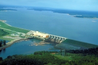
Aerial view of the West Point Dam & Lake as well as West Point, Georgia. This video was shot with a DJI Phantom 2 Vision+ quadcopter. West Point Lake is a man-made reservoir formed by the damming of the Chattahoochee River by the U.S. Army Corps of Engineers. This reservoir extends for about 35 mi (56 km) along the Chattahoochee River near the Alabama-Georgia state boundary. West Point Dam controls seasonal flooding and provides hydroelectric power. This reservoir also stores water during rainy periods, to be released later during dry periods, and hence helping to maintain the water level in the navigable inland waterway from Columbus, Georgia, southwards to the Gulf of Mexico at Apalachicola, Florida, along these two rivers: the Chattahoochee River and the Apalachicola River. West Point is a town in Troup County, with a small tail of the south end of town in Harris County, in the U.S. state of Georgia. As of the 2000 U.S. Census, this town had a total population of 3,382 people. The very small portion of this town in Harris County is part of the Columbus, Georgia Metropolitan Area, whereas the portion of the town in Troup County is part of the LaGrange, Georgia area.
|
Weitere Medien zu diesem Bauwerk |
||||||||||||||